
Tides Out Maps 7 views Claim this Business♡
×-
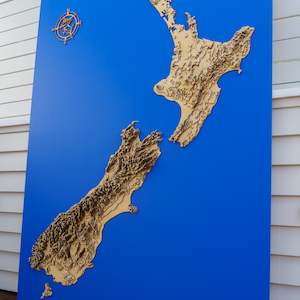 $1,999New Zealand Topo - XLThis is our topographic map of Aotearoa - New Zealand (NZ). Ever wanted to visualise some of the breathtaking landscape our country has to offer? From the mighty Southern Alps to the perfectly formed Mt Taranaki, this map shows New Zealand in a completely new light. Visually stunning and an excellen...Buy from Store ⦾ More like this 0 0
 -
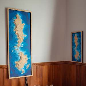 $1,099Poor Knights - XLThis is our XL wooden depth map of the Poor Knights. Due to its size, it's advised to enquire about this product before purchasing. If you've ever had the pleasure of visiting the Poor Knights islands, you'll know just how spectacular they are. Situated 22km offshore, north-east from Tutukaka, the P...Buy from Store ⦾ More like this 0 0
 -
 $1,099Hauraki Gulf - XLThis is our wooden depth map of the Hauraki Gulf. Due to its size, it's advised to enquire about this product before purchasing. This map shows much of the inner gulf, and displays some of it's myriad of islands. Amongst them are Rangitoto, Mototapu, Motuihe, Waiheke, Ponui, and Tiritiri Matangi. We...Buy from Store ⦾ More like this 0 0
 -
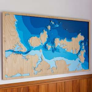
 $1,599Wider Hauraki Gulf - XLThis is our XL wooden depth map of the wider Hauraki Gulf. The Hauraki–Coromandel region has two distinct geographic zones – the flat farmland of the Hauraki plains and the mountainous Coromandel Peninsula. The Hauraki-Coromandel region has beautiful coastlines, remnants of gold mining, fertile ...Buy from Store ⦾ More like this 0 0
 -
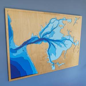 $1,199Manukau Harbour - XLThis is our XL wooden depth map of the Manukau Harbour. Due to its size, it's advised to enquire about this product before purchasing. The second largest harbour in New Zealand by area, the Manukau is extremely tidal. During each tide cycle about half its water squeezes through the harbour mouth tha...Buy from Store ⦾ More like this 0 0
 -
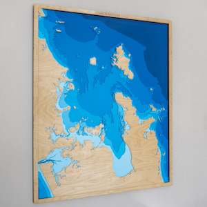
 $1,199Whangarei Harbour - XLThis is our wooden depth map of the Whangarei Harbour out to the Hen & Chicken Islands. A beautiful area essential for its bird life as well as a boat and fishing spot like no other. We design and build all our maps right here in New Zealand. To make geography accurate, each layer is laser cut. We t...Buy from Store ⦾ More like this 0 0
 -
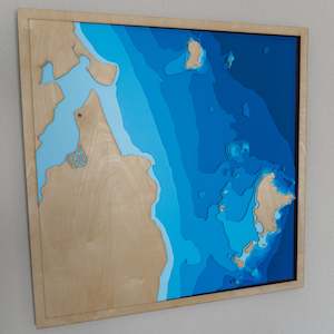 $999Pauanui-Tairua HarbourThis is our wooden depth map of the. This beautiful piece of coastline is located on the east coast of the Coromandel Peninsula. Both Pauanui and Tairua beaches are home to beautiful white sand and gentle surf break. This map also shows the myriad of islands sitting just off the coastline. The large...Buy from Store ⦾ More like this 0 0
 -
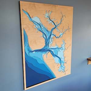 $1,199Kaipara Harbour - XLBy area, the Kaipara Harbour is one of the largest in the world. At high tide, it covers almost 1000 square km's. During low tide, the mudflats are exposed. The light blue layer of this map is largely walkable at low tide. Kaipara is named after the eating quality (kai) of the king fern (para).We de...Buy from Store ⦾ More like this 0 0
×